Indian rivers appear in almost every competitive examination, and the questions concentrate on a surprisingly narrow set of points: which river rises where, which tributary joins which, which city sits on which bank, and the handful of nicknames that recur year after year. Candidates lose marks here not from lack of study but from confusing pairs that look similar, particularly the west-flowing exceptions and the tributaries of the Ganga and Godavari systems. These twenty-five facts cover what is actually asked, grouped so the confusable pairs sit side by side rather than scattered.
Table of Contents
Why Indian rivers repeat as a topic
The subject is factual, bounded and easy to set unambiguous questions on, which makes it attractive to examiners. There is no interpretation involved: a river either rises in the Amarkantak plateau or it does not.
It also connects to several other sections of the syllabus. Dams and multipurpose projects, agricultural regions, major cities and state boundaries all attach to rivers, so a question about a river frequently tests something else at the same time.
Where the marks are actually lost
Rarely on the famous rivers. The Ganga and the Brahmaputra are known to everyone. Marks go on tributaries, on which of two similar rivers flows west, and on the state a source lies in. Those are the areas worth the revision time.
Himalayan rivers: the first ten facts
These are perennial, fed by both snowmelt and monsoon, and they form the great northern plains.
- The Ganga rises at Gangotri as the Bhagirathi and takes its name at Devprayag, where the Alaknanda joins it.
- The Yamuna rises at Yamunotri and is the longest tributary of the Ganga.
- The Brahmaputra is called the Tsangpo in Tibet, the Siang or Dihang in Arunachal Pradesh, and the Jamuna in Bangladesh.
- The Indus rises near Lake Mansarovar in Tibet.
- The five rivers of Punjab are the Jhelum, Chenab, Ravi, Beas and Sutlej.
- The Sutlej is the only one of the five that rises in Tibet, near Rakshastal.
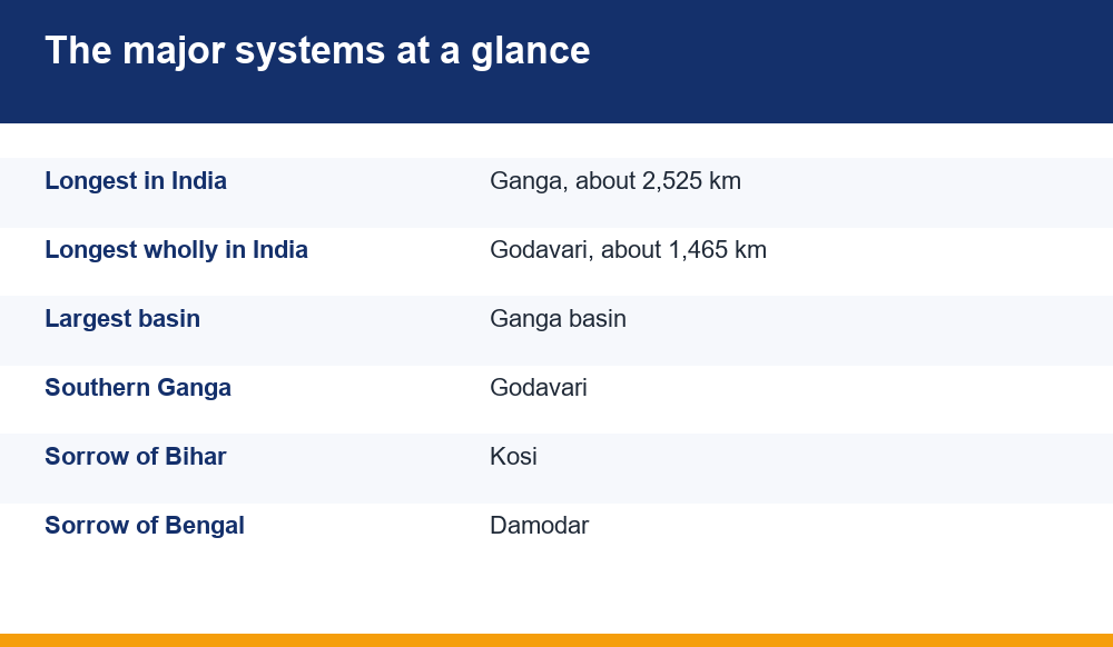
- The Kosi is known as the Sorrow of Bihar for its shifting course and flooding.
- The Gandak is called the Narayani in Nepal.
- The Ghaghara is the Karnali in Nepal and is among the Ganga’s largest tributaries by volume.
- The Chambal, famous for ravines, is a tributary of the Yamuna rather than of the Ganga directly.
Fact ten is a frequent trap. The Chambal, Betwa and Ken all join the Yamuna, not the Ganga, and questions are routinely set on exactly that distinction.
Peninsular rivers: facts eleven to eighteen
These are rain-fed and therefore seasonal, with broad shallow valleys and far more stable courses than their Himalayan counterparts.
- The Godavari is the longest peninsular river and the longest flowing entirely within India, rising at Trimbakeshwar in Nashik district.
- It is nicknamed the Dakshina Ganga, the Southern Ganga.
- The Krishna rises at Mahabaleshwar in Maharashtra.
- The Kaveri rises at Talakaveri in Karnataka and is sometimes called the Dakshina Ganga of the south.
- The Mahanadi rises in Chhattisgarh and the Hirakud Dam is built on it.
- The Damodar is the Sorrow of Bengal, and the Damodar Valley Corporation was India’s first multipurpose river valley project.
- The Tungabhadra is formed by the Tunga and Bhadra and joins the Krishna.
- The Indravati is the largest tributary of the Godavari.
The Godavari facts are the highest-yield group on this page. Longest peninsular, longest entirely within India, Southern Ganga, rises at Trimbakeshwar: four separate questions from one river.
West-flowing rivers and the exceptions
Most peninsular rivers flow east into the Bay of Bengal. The exceptions are examined heavily precisely because they are exceptions.
- The Narmada flows west and rises at Amarkantak in Madhya Pradesh.
- The Tapi, also written Tapti, flows west and rises at Multai in Betul district.
- Both flow through rift valleys, which is why they form estuaries rather than deltas.
- The Mahi and the Sabarmati also flow west into the Gulf of Khambhat.
| River | Direction | Mouth |
|---|---|---|
| Ganga, Godavari, Krishna, Kaveri, Mahanadi | East | Delta into Bay of Bengal |
| Narmada, Tapi, Mahi, Sabarmati | West | Estuary into Arabian Sea |
| Indus and Punjab rivers | West and south | Arabian Sea |
The delta-versus-estuary point is worth holding onto. East-flowing rivers deposit sediment and build deltas; the rift-valley rivers carry it straight out, which is why the Narmada and Tapi have none.
Confluences and places worth memorising
Confluence questions are common and easy marks once the handful of famous ones are fixed.
- Devprayag: Bhagirathi meets Alaknanda to form the Ganga.
- Prayagraj: the Ganga meets the Yamuna, the Sangam.
- Haridwar: where the Ganga enters the plains.
- Majuli, on the Brahmaputra, is among the largest river islands in the world.
The Panch Prayag of Uttarakhand, the five confluences of the Alaknanda, appear regularly: Vishnuprayag, Nandprayag, Karnaprayag, Rudraprayag and Devprayag, in order from upstream.
City-on-river pairings are the other standard format. Delhi on the Yamuna, Kolkata on the Hooghly, Patna on the Ganga, Surat on the Tapi, Ahmedabad on the Sabarmati, Nashik on the Godavari, Hyderabad on the Musi.
Nicknames examiners favour
A short list, almost all of which have appeared in recent years.
- Sorrow of Bihar: Kosi
- Sorrow of Bengal: Damodar
- Dakshina Ganga: Godavari
- Ganga of the South: also used for the Kaveri in some sources
- Sorrow of Assam: Brahmaputra
The fourth entry is the one to handle carefully. Different sources apply the Southern Ganga label to both the Godavari and the Kaveri, and where an examination uses it unqualified the Godavari is the safer answer because it is the more widely printed association.
The three mistakes candidates repeat
Longest river confusion. The Ganga is the longest in India; the Godavari is the longest flowing entirely within India. Both statements are true and the question usually turns on that qualifier.
Tributary misattribution. The Chambal, Betwa and Ken join the Yamuna. The Son, Gandak, Kosi and Ghaghara join the Ganga. Mixing these two lists is the most common single error on this topic.
Source states. The Sutlej rises in Tibet while the other four Punjab rivers rise in Indian territory. The Narmada and Son both rise at Amarkantak and flow in opposite directions, which is a favourite question because it sounds implausible and is true.
How to revise this without a map
Most candidates revise rivers by reading lists, which is why the confusable pairs stay confusable. Two approaches work better.
Group by what is being asked rather than by geography. Make one list of all sources, one of all tributaries, one of all nicknames, one of all cities. Examiners ask within a category, so revising within categories matches how the recall will be tested.
- Draw the outline of India freehand and place only the major rivers; accuracy matters less than repetition
- Write the confusable pairs on facing lines so the contrast is visible
- Test yourself on the qualifier, not the fact: longest in India versus longest within India
- Revisit the tributary lists weekly, since they decay fastest
- Attach each dam to its river as you learn it, since the two are examined together
The freehand map is worth more than it appears. Drawing the course of a river, even badly, fixes the direction of flow in a way that reading never does, and direction of flow is what the west-flowing questions are testing.
The same category-based method works across the static portion of general knowledge generally, and we applied it to another high-frequency topic in our notes on countries, capitals and currencies.
Dams and projects asked alongside Indian rivers
Questions on Indian rivers very often arrive attached to a dam, because the pairing tests two facts in one line. Learning them together rather than separately is markedly more efficient.
- Bhakra Nangal on the Sutlej, among the highest gravity dams in the country.
- Hirakud on the Mahanadi in Odisha, one of the longest earthen dams in the world.
- Sardar Sarovar on the Narmada in Gujarat.
- Nagarjuna Sagar on the Krishna, between Telangana and Andhra Pradesh.
- Tehri on the Bhagirathi in Uttarakhand.
- Mettur on the Kaveri in Tamil Nadu.
- Tungabhadra on the Tungabhadra, shared between Karnataka and Andhra Pradesh.
The Damodar Valley Corporation deserves separate attention as the first multipurpose project of independent India, modelled on the Tennessee Valley Authority. It appears in general knowledge sections as frequently as in geography ones.
A useful revision habit: whenever a dam is learned, write the river beside it and the state beneath it. Three facts stored as one unit are recalled together, and examiners rarely ask for any of the three in isolation.
Two further groupings are worth adding to the same revision sheet, because they are examined with similar frequency and are quickly confused with each other.
The first is river-linked national parks and sanctuaries: Kaziranga beside the Brahmaputra, the Sundarbans in the Ganga-Brahmaputra delta, and the National Chambal Sanctuary along the Chambal. The second is the inland waterways, where National Waterway 1 runs on the Ganga between Haldia and Prayagraj and National Waterway 2 on the Brahmaputra.
A final word on how deep to go. Indian rivers can be studied endlessly, and past a point the return falls sharply. The sources, the major tributaries, the west-flowing exceptions, the nicknames, the famous confluences and the dam pairings cover the overwhelming majority of what is actually set. Candidates who master that list reliably outperform those who have read far more and organised none of it.
For anyone preparing across multiple examinations, note that the depth expected varies. State-level papers tend to concentrate on rivers within the state and its immediate neighbours, while national papers stay with the major systems and the standard nicknames. Checking two or three previous years of the specific paper you are sitting is worth more than any general list, including this one, because it shows exactly which of these facts that examiner actually uses.
Keep a single sheet rather than notes scattered across chapters. Rivers connect to geography, to general knowledge, to current affairs when a dispute or a project is in the news, and to the environment section. One consolidated page revised weekly serves all four, which is a better use of the time than reading the same material four times in four places.
Finally, revise this topic early in a preparation cycle rather than late. It is entirely static, it does not change between years, and once fixed it stays fixed with very little maintenance.
Frequently Asked Questions
Which is the longest river in India?
The Ganga, at roughly 2,525 km. The Godavari is the longest river flowing entirely within India, at about 1,465 km. Questions on this topic almost always turn on that qualifier, so read whether the paper asks for longest in India or longest within India.
Which Indian rivers flow west?
The Narmada and the Tapi are the main west-flowing peninsular rivers, both running through rift valleys, along with the Mahi and the Sabarmati. Because they flow through rift valleys, the Narmada and Tapi form estuaries rather than deltas.
Which rivers are tributaries of the Yamuna rather than the Ganga?
The Chambal, Betwa and Ken join the Yamuna. The Son, Gandak, Kosi and Ghaghara join the Ganga directly. Confusing these two lists is the single most common error candidates make on this topic.
Why is the Kosi called the Sorrow of Bihar?
Because it shifts its course dramatically across the plains and causes severe flooding. The Damodar carries the same nickname for Bengal, and the Damodar Valley Corporation was India’s first multipurpose river valley project, which is frequently asked alongside it.
Where does the Ganga get its name?
At Devprayag in Uttarakhand, where the Bhagirathi, which rises at Gangotri, meets the Alaknanda. Upstream of that confluence the river is the Bhagirathi rather than the Ganga, which is a detail examiners use regularly.